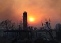
A new wrinkle formed in Southern California’s weather picture today, with forecasters warning that a round of gusty Santa winds expected to last through Saturday will create an elevated danger of wildfire.
In the meantime, there were more frigid early-morning temperatures today, but, reflecting a warming trend that got underway Wednesday, no freeze warning was in effect in Los Angeles County. A less serious frost warning was issued for the San Fernando Valley and the Santa Monica Mountain recreational area and scheduled to expire at 9 a.m.
Early-morning temperatures in the western San Fernando Valley were expected to drop into the mid-30s, said a National Weather Service statement.
The NWS, in describing the approaching fire danger, said high pressure over the Great Basin and low pressure over California will result in “a weak to moderate cold Santa Ana wind event over much of Los Angeles and Ventura counties Thursday through Saturday.”
The offshore winds will peak on New Year’s Day, when the humidity level will be low — in the teens.
“Vegetation across Southwest California is very dry, so if fire ignition does occur, conditions may be favorable for extreme fire behavior that could threaten life and property,” an NWS statement said.
The NWS forecast sunny skies today and highs of 48 in Palmdale; 50 in Lancaster; 51 on Mount Wilson; 57 in Saugus; 62 in Burbank; 63 in Avalon; 64 in Pasadena and Woodland Hills; 65 at LAX and in downtown L.A. and San Gabriel; and 66 in Long Beach.
Temperatures will be a degree lower in many communities on a sunny New Year’s Day, rise by a few degrees under partly cloudy skies on Saturday, drop back a bit under mostly cloudy skies Sunday, followed by rain from Monday through Wednesday, a stretch when temperatures will range from the mid to the low 60s.