Rapidly Growing Blaze Fueled by Santa Ana Winds Threatens Homes Near Pepperdine
UPDATE: Zuma Beach Disaster Information Center is now active as of 10:54 am, December 10, 2024.
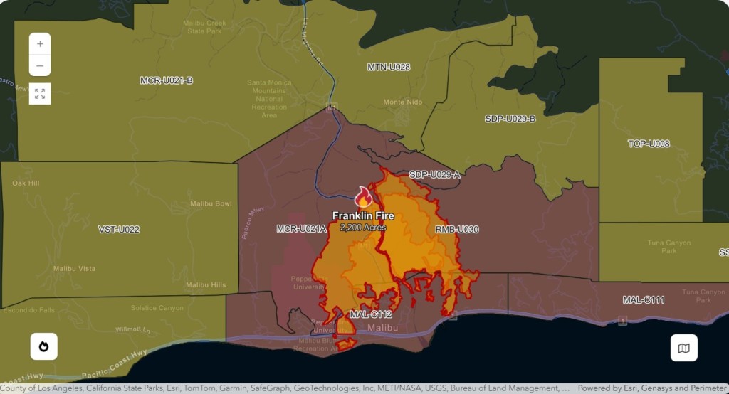
UPDATE: 2,593 acres have burned, some homes are damaged and an unknown number have been destroyed. 700 firefighters have been deployed. The cause of the fire, which began at 11:00 p.m. is unknown and is under investigation.

UPDATE as of 8:00 a.m. LA County Fire: Evacuation Orders and Evacuation Warnings:
Evacuation Orders have been issued for the following areas:
- South of Piuma Road, north of the Pacific Ocean coastline, east of Puerco Canyon Road/Corral Canyon Park, west of Los Flores Canyon Road
- Between the Pacific Ocean coastline and Tuna Canyon Park to the west of Tuna Canyon Road
Evacuation Warnings:
- East of Trancas Canyon Road and Kanan Dune Road, west of Topanga Canyon Blvd/Surfview Drive, south of Mulholland Highway, north of the Evacuation Order boundary which Includes Topanga Zone 8 and 10, Between Stunt Road to the north and Los Flores to the south, East of Carbon Beach Terrace, west of Old Malibu Road, north of Pacific Crest highway
- View a map of Evacuation Areas on Genasys Protect
Evacuation Shelters
- Palisades Recreation Center – 851 Alma Real Drive, Pacific Palisades, CA 90272
- Pets in crates welcome
- Small Animals:
- Agoura Animal Care Center – 29525 Agoura Road, Agoura Hills, CA 91301Pets in crates welcome at the Evacuation Shelter at Palisades Recreation Center – 851 Alma Real Drive, Pacific Palisades, CA 90272
- Pierce College: 6201 Winnetka Ave, Woodland Hills, CA 91367
UPDATE: Road Closures:
Pacific Coast Highway (SR-1) is closed in both directions between Kanan Dume Rd and Topanga Canyon Blvd in the City of Malibu due to the Franklin Fire. Avoid the area.
Malibu Canyon Road is Closed. Only Open To Emergency Vehicles from Mulholland Highway to Pacific Coast Highway.
Old Topanga Canyon Road is Closed. Only Open To Residents & Emergency Vehicles from Mulholland Highway to Topanga Canyon Boulevard.
Los Virgenes Road at Mulholland Highway
Pepperdine Update as of 8:05 a.m.: After assessing campus conditions at daybreak, the university is lifting the shelter-in-place protocol. Campus conditions are safe for members of the community to return to student residences and on-campus homes. The community is strongly encouraged to remain on campus and stay off Malibu roads as first responders continue to respond to the Franklin fire, which continues to threaten Malibu. Additionally, ongoing fire suppression efforts on campus continue, and residents are encouraged to limit driving on campus to allow first responders to respond to spot fires that continue to flare up around campus. Power remains out for much of the campus and Malibu area. The red flag warning continues as gusty winds remain. If conditions worsen, we may have to reinstitute our shelter-in-place protocol.
UPDATE: Gail Pinsker, Community & Public Relations Officer, Santa Monica – Malibu Unified School District as 5:27 a.m.: All Malibu schools in the Santa Monica-Malibu USD are closed today, Dec. 10, 2024 due to no power, a fire in progress and other fire concerns. This includes: Webster Elementary, Malibu Elementary, Malibu Middle and Malibu High.
UPDATE: LA County Public Works as of 4:20 a.m.: Malibu Canyon Road from Mulholland Highway to Pacific Coast Highway will be closed to the public. Only emergency vehicles will be allowed access. For updates on County road closures, visit http://lacounty.pw/roads
UPDATE: LASD Lost Hills Station #FranklinFire Update 12/10/24 3:47 a.m.: The fire has spread to 1,822 acres Evacuation Order in place for the following zones: MCR-U021A RMB-U030 MAL-C112 MAL-C111 Know your zone and stay up to date with evacuations: https://protect.genasys.com/search or https://lacounty.gov/emergency/
UPDATE: 12/10/2024, 3:00 a.m. from the City of Malibu – The Franklin Fire, which started in Malibu Canyon, has spread south across PCH to Malibu Road near Webb Way, and across PCH into the Malibu Pier area, threatening structures by Malibu Pier, Malibu Rd, Malibu Knolls, Sweetwater Mesa.
LA County Sheriffs are conducting evacuations door-to-door. The fire has expanded to1,674 acres and is approaching the hillside behind the Santa Monica College campus at Malibu.
Mandatory evacuations are in effect for all of Zones MAL-C112 and MAL-C111 and an Evacuation Warning for MAL-C113 in Malibu due to the Franklin Fire in Malibu Canyon. MAL-C111 *Approximately Tuna Creek to Carbon Beach. MAL-C112 *Approximately Carbon Beach to Puerco Canyon. MAL-C113 *Approximately Puerco Canyon to Trancas Canyon.
Pepperdine University updated at 3:28 a.m., “The University understands the worst of the fire has pushed past Pepperdine. However, there are smaller spot fires on campus that are not threatening life or structures, and fire resources remain on campus to address these spot fires as they occur. Additionally, power remains out for much of Malibu and therefore, to ensure the safety of our community, we will maintain the shelter-in-place protocol until at least daylight. The EOC will continue to update the community.”
This breaking news story will be updated as events unfold.
Mandatory evacuations for Malibu residents in the Serra Retreat neighborhood, areas east of Malibu Canyon Road, and south of Piuma Road have been issued as of 12:06 a.m. The fire, dubbed the Franklin Fire, is located three miles north of Pacific Coast Highway (PCH) in Malibu Canyon, and has rapidly grown from 100 acres to over 850 acres in two hours, as of 2:14 a.m., driven by strong Santa Ana winds and extremely low humidity according to KCAL News.
The Los Angeles County Fire Department is battling the blaze with multiple units. The City of Malibu has activated its Emergency Operations Center (EOC), and officials have issued a third alarm for the fire. The LA County Emergency Operations Center has activated the Emergency web page for the #FranklinFire. For details about evacuation areas and other information, visit http://alertla.org. On social media, follow @LACoFDPIO and @LHSLASD.
Pacific Coast Highway is closed between Carbon Canyon Road and Corral Canyon Road except for evacuations, according to Caltrans District 7’s Twitter account. City of Malibu issued an update at 1:57 a.m. that brush fire road closures in Malibu include PCH closed Las Flores to Corral Canyon and Las Virgenes, closed from Mulholland to PCH.
The affected evacuation area is Genasys Zone MAL-C112. Residents are urged to follow police and fire officials’ evacuation directions immediately.
City of Malibu Update: 12/10, 1:20 AM – Large animal evacuation site at Palisades Recreation Center at 851 Alma Real Dr. Large animal shelter available at Pierce College in Woodland Hills (6201 Winnetka Ave at Victory Blvd). Brush fire in Malibu Canyon, 3 miles north of PCH.
Pepperdine University has issued two updates “The University is now activating its shelter-in-place protocol. All community members on the Malibu campus are directed to shelter in place in the Tyler Campus Center or Payson Library. Despite any evacuation orders from Malibu city or surrounding areas, the University community should follow University instructions. We do not evacuate the campus even when surrounding areas might – this shelter-in-place protocol is approved by LA County Fire and executed with their cooperation.”
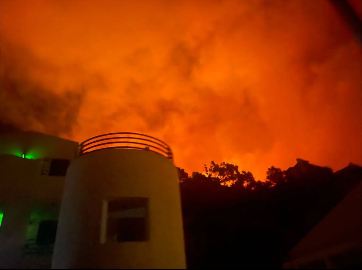
In the second update at 2:44 a.m., Pepperdine University has canceled classes and finals for Tuesday. “Normal operations on the Malibu Campus are suspended for Tuesday. This includes canceling classes and finals for the day. Critical support personnel should connect with their supervisors about whether they are needed to physically report to the Malibu campus for their regular work shift. All other staff should connect with their supervisors and work remotely if possible. The Pepperdine community continues to shelter in place in Payson Library and the Tyler Campus Center. The Franklin fire has grown to 814 acres and flames are visible from the Malibu campus. There are numerous LA County Fire Department engines on campus and their helicopters are using the lakes in Alumni Park to pick up water to drop on the fire from above.”
Flames can be seen from Payson Library where students are sheltering in place. This video comes from Pepperdine student Matthew Morrison:
A Red Flag Warning remains in effect, signaling extremely dangerous fire conditions. Southern California Edison (SCE) has initiated Public Safety Power Shutoffs (PSPS) in large portions of Malibu, leaving many residents without power. For updates on outages, visit SCE’s website.
Residents should prepare for potential fires, hazardous road conditions, and traffic signal outages. Motorists are reminded to stop completely at malfunctioning traffic lights.
- Review evacuation plans, emergency supplies, and reunification locations.
- Make arrangements for pets, livestock, and medical or mobility devices in advance.
- Check on elderly or disabled neighbors to ensure they are aware of evacuation orders.
- Monitor emergency updates on local news outlets and AM/FM radio, including 99.1 FM KBUU, which remains operational during power outages.
Residents are encouraged to sign up for alerts and track updates at MalibuCity.org/alerts. Additional resources include the LA County Power Outage Preparedness Guide and the Genasys Emergency and Evacuation website.
For more information, visit MalibuCity.org or follow the city on social media for real-time updates.


