
Part II: The Stakes Along the Shore

Pull up the City of Santa Monica’s official Coastal Zone map, and the stakes become clear. The red-shaded area stretches from the northern city limit to the Venice border—the zone where Commission oversight currently applies. The blue hatched area displayed represents the 300-foot buffer from the beach where AB1740 would still require Commission review.
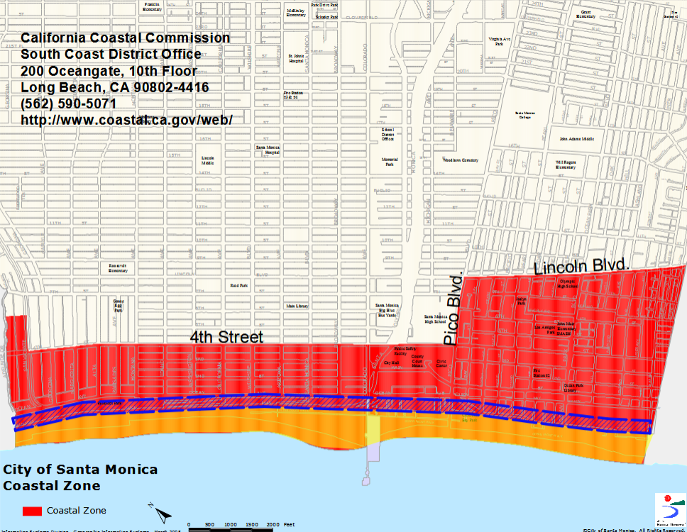
Everything else in red? Under the bill, a new locally-controlled process would apply—one that critics say could open the door to the ‘Miamification’ of Santa Monica’s coast. However, ‘Miamification’, as our city has been called, may understate the loss to be incurred. That is, what AB 1740 threatens is not merely architectural character but environmental memory itself—the sense of place that accumulates over generations, anchored in specific views, specific light, the particular way afternoon shadows fall across streets, and parks that still remember when the ocean was the organizing principle of civic life.
The multifamily-zoned parcels within the Coastal Zone but outside that narrow buffer include areas along Wilshire Boulevard, Arizona Avenue, Santa Monica Boulevard, Colorado Avenue, Broadway, and into Ocean Park. These are precisely the locations where new housing exempt from Coastal Commission review could rise.
Under California’s density bonus laws and recent state legislation, affordable housing projects already qualify for significant height bonuses. Combined with AB1740’s elimination of Commission oversight, buildings far taller than current norms could be approved without the independent review that has shaped coastal development for five decades.
Residents in adjacent areas—including much of the Wilmont neighborhood and Ocean Park— would experience direct impacts when taller buildings appear; similarly losing views, natural light, and the coastal breezes that define life near the ocean.
The Federal Alternative
While Sacramento debates reducing oversight, Washington is studying whether to increase it. The National Park Service study must determine whether the coastline meets four criteria:
nationally significant resources, suitability for the park system, feasibility of management, and whether NPS management would be superior to other approaches.
‘We invite you to participate in this process,’ said Sarah Bodo, project manager for the NPS Denver Service Center, during a February 11 public meeting. ‘Your thoughts and ideas are important to us.’
If designated, management could take several forms. Under a ‘partnership park’ model, the Park Service would directly own only a small portion of land, deferring to existing agencies for land use regulations. California’s Coastal Commission, state government, and local municipalities could all retain some element of control depending on final agreements. However, new, higher buildings across from our unique Palisades Park would impact viewing from the shoreline to the world-famous bluff.
Critically, NPS official Carrie Miller noted that lands directly owned by the Park Service are ‘protected in perpetuity under the agency’s Organic Act.’ A designation could also unlock federal funding not currently available.
That phrase—in perpetuity—carries weight that no local zoning variance can match. It speaks to a different relationship with time, one that measures value not in development cycles but in generations. The NPS study asks whether this coastline holds significance that transcends the politics of any single decade.
Who Benefits from AB1740?
The bill’s co-sponsors reveal the interests at play.
Streets for All, a transportation advocacy organization, has pushed for road reconfigurations and parking elimination, and its CEO argues the bill ‘modernizes that approach and returns local control to cities that have spent the time and resources to build out multimodal infrastructure.’ Abundant Housing LA advocates for increased housing development with reduced regulatory barriers. Assemblymember Zbur frames the legislation as modernization:
‘Instead of enhancing public access, current standards often put needless barriers in front of housing, bike lanes, and other projects that achieve climate goals and pose no risk to sensitive coastal resources.’
The timing may be deliberate. With the 2026 FIFA World Cup and 2028 Olympics approaching, AB 1740 is positioned as a tool to accelerate housing and infrastructure in preparation for the massive crowds expected in coastal areas.
The Democratic Deficit
The 1990 election established a clear precedent: when Santa Monica voters are asked directly about coastal development, they choose protection. Proposition S passed, and voters used the initiative process to override City Council decisions they believed betrayed the public interest.
Thirty-five years later, it appears City staff may have found a way around that democratic check. Based on former Councilmember accounts, vague ‘council priorities’ from 2023 were apparently sufficient to commit Santa Monica to a position on coastal development—without a public vote or even full City Council deliberation. The democratic check that Sharon Gilpin and her neighbors fought to establish—the principle that residents would have their say on their shore— appears to have been quietly bypassed, not overturned but simply… forgotten.
Questions That Demand Answers
The circumstances surrounding Santa Monica’s sponsorship of AB 1740 raise fundamental questions about governance and transparency:
What specific ‘council priorities’ were cited to justify this commitment?
Who authorized communication with the Sacramento lobbyist regarding AB 1740, and under what authority?
Did the City Manager’s office direct this action?
Why weren’t residents informed before the City’s name was attached to legislation with such far-reaching implications for residents’ own welfare?
Does the Council intend to review and vote on whether to continue supporting this bill now that its contents are public?
What Residents Can Do
AB 1740 has not yet been heard in policy committee. Residents can make their voices heard in Sacramento and at City Hall.
The broader question extends beyond any single bill or study: who should control what happens to the coast? Voters who established the Coastal Commission believed the answer was an independent state body, insulated from local development pressures. AB 1740’s proponents believe transit-rich cities have earned the right to decide for themselves.
Meanwhile, the federal government is quietly asking whether this same coastline deserves protection in perpetuity. What hangs in the balance is not just regulation but remembrance—
whether Santa Monica’s shore will remain a site of environmental memory, or become another coastline that forgot itself.
Santa Monica residents deserve to know how their city championed an obscure single vision for the coast. As noted, Santa Monica’s voters, when their leaders thought to ask them, answered clearly: they wanted their beach and its views protected. They wanted it remembered—not reimagined beyond recognition.
Sources:
City of Santa Monica Coastal Zone map (Information Systems Division);
AB 1740 bill text (California Legislative Information);
National Park Service study (parkplanning.nps.gov/LosAngelesCoastal);
Los Angeles Times, November 8, 1990;
Social media sharing between former Councilmember Oscar de la Torre, current Councilmember Lana Fernandez Negrete, and participants during their Facebook exchanges.
Jack Hillbrand, Architect, for SMa.r.t. Santa Monica Architects for a Responsible Tomorrow Web: www.santamonicaarch.wordpress.com/writing
Mario Fonda-Bonardi AIA, Former Planning Commissioner, Robert H. Taylor AIA, Dan Jansenson, Former Building & Fire-Life Safety Commissioner, Sam Tolkin, Former Planning Commissioner, Michael Jolly ARE-CRE, Jack Hillbrand AIA, Landmarks Commission Architect, Phil Brock (Mayor, ret.), Matt Hoefler, NCARB, Architect, Heather Thomason, Community Organizer, Charles Andrews, Journalist, Columnist


